Dresden from historical perspectives – a 4D city model for virtual exploration
Have you ever wondered how (urban) photography has changed over time? For example, was the Kronentor photographed more often or from different perspectives at the beginning of the 20th century than during the GDR era?
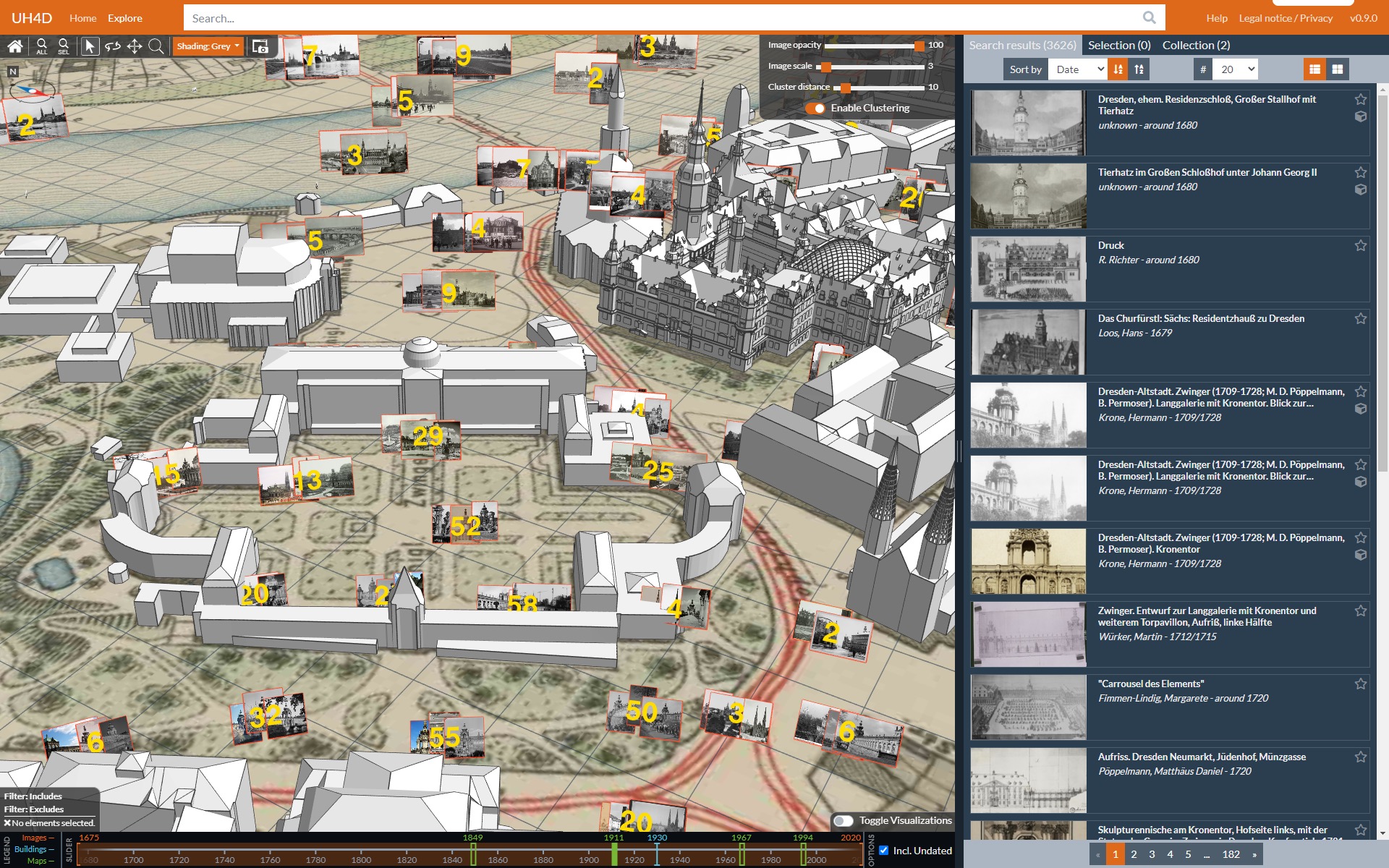
You can find answers to these questions here: The junior research group HistStadt4D, a group of young scientists from the TU Dresden and the University of Würzburg, is developing a digital online application, a so-called 4D browser (Fig. 1). This freely accessible tool includes a virtual three-dimensional (3D) city model of Dresden. Users can move around freely and explore Dresden from any perspective. The 4D browser is being developed especially for art and architecture historians and historians as well as for anyone interested in historical photographs and city history.

Fig. 1 Digital 3D city model of Dresden in the 4D browser.
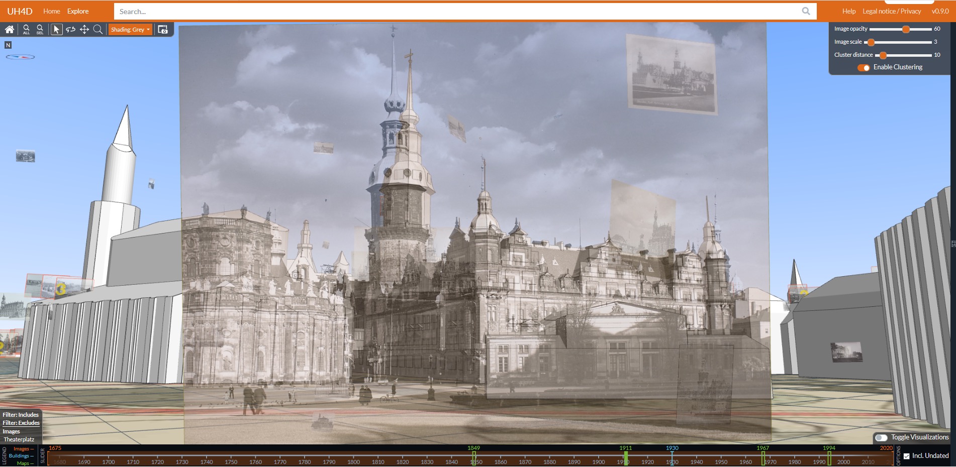
A special feature is that hundreds of historical photographs are located in the city model (Fig. 1). This means that the exact camera position - i.e. the position of the photographer - was determined from these historical images. When the website is opened, the photographs are in several clusters to ensure an overview. When zooming in on a building, the individual photos become visible. If you double-click on a photo, the user is zoomed to the respective position. The 'Image Opacity' control makes the photograph translucent and the 3D model behind it helps to identify the buildings shown (Fig. 2). One of four historical maps can be displayed for better orientation (see green markers on the timeline below the 3D window in Fig. 1; to turn off the map, click on the active marker a second time). This makes it possible to see at a glance what the road network and buildings in Dresden once looked like. The street names of the time are also legible.

Fig. 2 Semi-transparent historical photograph at its location with 3D model behind it.
The buildings shown as 3D models also make it possible to filter for specific photos. Right-clicking on the building opens the corresponding menu. When locating the photographs at the point where they were taken, the photos were blended with the 3D model, so they can now be found quickly and easily using the 3D model. When searching in tried-and-tested digital image repositories, you always have to rely on the search term you entered being in the image information (metadata).
In order to be able to test the application and its functionalities, 3626 photographs are currently integrated into the platform, of which around 700 were manually located. One research focus is the automatic location of these images using photogrammetric methods and is currently in the test phase. All photos come from the archive of the German Photo Library and date from the beginning of photography around 1820 to the present day. The German Photo Library offers other interesting photos of Dresden and of course this one archive does not include all the photographs that have ever been taken of Dresden. As a result, only a portion of the city's photographs can currently be seen in the digital 3D model.
To gain a deeper insight into earlier times in Dresden, the application offers a timeline that can be found below the 3D window. The component of time as the fourth dimension turns the 3D city model into a 4D city model. By moving the two orange sliders on the timeline, any time window can be set for further filtering. Then only photos from this selected period are visible in the city model. This function is therefore ideal for filtering the hundreds of photographs in the 4D browser. The (filtered) photos are listed on the right-hand side along with brief information (title, photographer, year).
But the timeline can do even more! If you move the blue slider, buildings are displayed according to the selected point in time. If a building no longer existed at the selected point in time, it will also disappear from the 3D model (Fig. 3). This gives you a quick overview of how the city and its buildings have changed over time.

Fig. 3 4D city model of Dresden with construction status in 1930 (left) and 2004 (right).
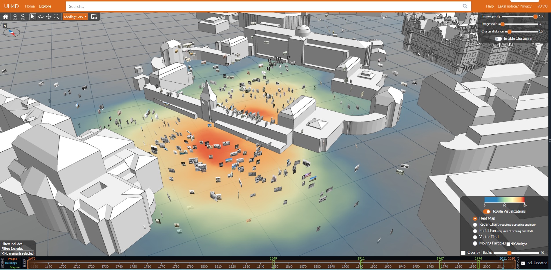
But how do you find out from which perspectives the Kronentor was photographed most often and in which period many or few photos were taken? The 'Toggle Visualizations' function (see bottom right corner of the 3D window) promises answers. If, for example, the heat map is selected from the list offered there, a color gradient appears under the 3D city model (Fig. 4). Many photographs were taken in the red areas, slightly fewer in the orange areas. The more the color changes from yellow to green to blue, the fewer photos were taken in these areas. In this way, it is easy to see where photographers once stayed more often to take a photo of a particular building and where they did so less often. If, in addition to this color visualization, the sliders in the timeline are also moved, it can be observed whether the photographers' behavior has changed over time. In the other variants of the visualizations, the focus is on the shooting directions and viewing angles.

Fig. 4 Color visualization using a heat map to indicate frequency of photographers (red-blue / more-less), digital 3D city model of Dresden in the 4D browser.
We carry out usability tests to really ensure that the application offers users added value. Our goal with these user studies is to find out which functions are used successfully and where there are difficulties. Results included, for example, user suggestions for improving the interface and the desire for a faceted search (a faceted search includes a predefined classification according to selection criteria such as photographer, location, image size, etc., so that the search results can be narrowed down). We collected all comments and sorted them by priority. In the next step, we want to revise the interface with the help of paper prototyping. Colleagues from the Usability (UX) cluster at the Media Center will support us in this.
Do you also feel like discovering Dresden from new – or rather historical – perspectives?
Enjoy exploring virtually at: http://4dbrowser.urbanhistory4d.org/
Website of the junior research group HistStadt4D: http://www.urbanhistory4d.org/
The project is funded by the Federal Ministry of Education and Research under the funding code 01UG1630.
Photo credits for historical photographs: SLUB/Deutsche Fotothek
Screenshots: HistStadt4D 2020
Project collaborators and authors of this article: Heike Messemer, Cindy Kröber, Ferdinand Maiwald, Jonas Bruschke


1 Response